
Mehitamata õhusõidukite demolend Eestis aitab realiseerida Euroopa visiooni turvalisest õhuruumi kasutamisest kõigile õhusõidukitele

The two demos marked first steps in the Gulf of Finland (GOF) U-space very large demonstrator, but a leap for the implementation of unmanned traffic management (UTM) in Europe. For the first time ever, general aviation aircraft, drones, and recreational remote-controlled model aircraft safely shared the airspace above and around an operational airfield during the first demo at the East Helsinki Aerodrome in Pyhtää, Finland, on 11 June. During the second demo on 14 June, urban drone operations above and below 500 feet were demonstrated in controlled airspace in Tallinn, Estonia.
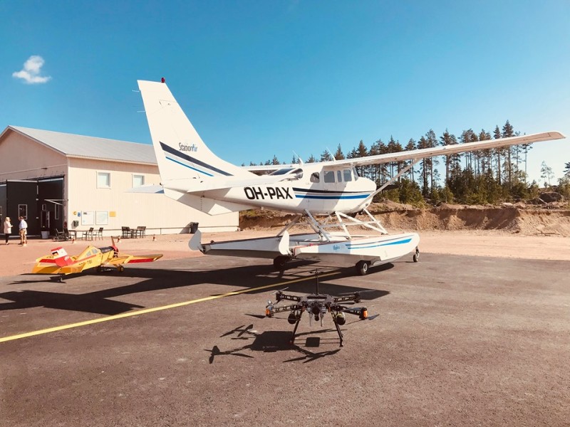
Weeks of intensive preparation work have already paid off: Two out of eight demos of the SESAR Joint Undertaking (SESAR JU) GOF U-space project have been successfully completed. On 11 June, at Pyhtää East Helsinki Aerodrome in Finland, we demonstrated how cooperation at uncontrolled airfield is enabled between RC model fliers, drone professionals, and General Aviation to safely share the same airspace within line-of-sight of each other. In a world-first demonstration, the GOF Flight Information Management System (FIMS) routed data between three UTM platforms and the air traffic management (ATM) domain. This demonstration showcased the core idea of U-space, increasing transparency for all users. In addition to drone operators, it is also relevant to General Aviation and other airspace users, who are able to access digital tools that the current UTM solutions provide in order to create situational awareness for everyone. Mobile 4G networks were used to relay situational awareness data to both ground crew and general aviation flying up to 2000 feet, tracking targets using transponders, FLARM, and mobile network-based position trackers.
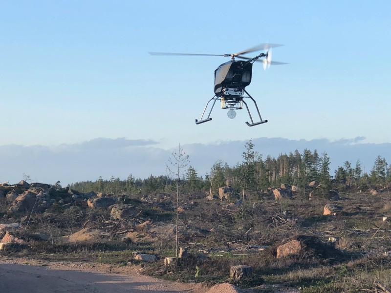
During the second demonstration, which took place on 14 June in Tallinn, Estonia, drone operations were successfully flown in controlled airspace. The purpose of the demo flights was to determine how several UTM’s can service the same airspace and how it is possible to share reliable information with all airspace users by offering real-time situational awareness to air traffic operating in the vicinity. During the demo flight it was established that the delivery of information required for drone operators to operate their drones is possible by creating a common system, integrating independent technical solutions by different UTM services providers. The trial also showcased how authorised drones can operate with privileged status in otherwise restricted areas. One of the missions simulated a traffic accident to demonstrate how public authority is able to create a temporary flight restriction area around the accident scene, as well as monitor compliance from drone operators, while performing remote identification of drones and pilots through the U-space systems, agnostic of what UTM service the drone pilot was using. Only the Police drone had access to the restricted area to provide law enforcement with high-definition, real-time video, and pictures from the scene, while non-authorised drone pilots were alerted by the system to land immediately. The next demo will focus on long-range, low-level powerline inspection in Läänemaa rural areas in western Estonia.
In August, the GOF U-space demonstrations will continue with a maritime search and rescue exercise involving drones, several aircraft and surface vessels in cooperation with the border guard on 13 August in Hiiumaa, Estonia, long-range forest survey on 16 August, operation in densely populated area with Police cooperation in Helsinki on 20 August, and on 22 August, international parcel delivery with drones over the Gulf of Finland will take place between Torbacka, Finland, and Muraste, Estonia. The demonstration series will be completed by an urban Volocopter air taxi flight from the Vantaa international airport at the end of August 2019. These trials are open to qualified visitors only.
The GOF U-space project with a broad consortium of 19 members demonstrates that Europe is on course with its implementation of U-space, an initiative that aims to ensure safe and secure drone traffic management, taking into account the rapid growth in the use of drones. The GOF concept enables shared situational awareness for all aviation stakeholders. The success of the project is based on deep Air Traffic Management (ATM) experience of the consortium members, including three world-leading UTM (Unmanned Traffic Management) technology vendors and two Air Navigation Services Providers, developing interoperability and data-sharing solutions which are aligned with SESAR JU’s overall U-space architecture. In addition to air traffic management, large-scale drone use will rely on scalable radio communication systems (e.g. mobile networks) and weather information, which are also trialled in the project.
This U-Space project is one of several research projects of the SESAR Joint Undertaking, which has received funding within the framework of the European Union's Connection Europe Facility (CEF) programme under grant agreement SJU/LC/343-CTR.
About SESAR
As the technological pillar of the Single European Sky initiative, SESAR aims to modernise and harmonise air traffic management in Europe. The SESAR Joint Undertaking (SESAR JU) was established in 2007 as a public-private partnership to support this endeavour. It does so by pooling the knowledge and resources of the entire ATM community in order to define, research, develop and validate innovative technological and operational solutions. The SESAR JU is also responsible for the execution of the European ATM Master Plan which defines the EU priorities for R&D and implementation. Founded by the European Union and Eurocontrol, the SESAR JU has 19 members, who together with their partners and affiliate associations will represent over 100 companies working in Europe and beyond. The SESAR JU also works closely with staff associations, regulators, airport operators, airspace users and the scientific community.
About Lennuliiklusteeninduse AS (EANS)
Estonian Air Navigation Services (EANS, Lennuliiklusteeninduse Aktsiaselts) is efficiently operating public limited company acting under private law, which provides Air Navigation Services in Tallinn FIR and at Tallinn and Tartu aerodromes. The Company has a long and fruitful experience in the modernisation of Air Traffic Management (ATM) and Aeronautical Information Management (AIM) systems, airspace organisation and procedures design and implementation. EANS has experience in the realisation of EU funded development and implementation projects.
In year 2013 new PRNAV/CDA procedures were implemented in Tallinn TMA and Sherpa project were successfully finalised– building capacity for SBAS LPV procedures design and implementation, ASM Tool as well as DLS service implementation. In 2012-2014 we worked on IDSG IDP implementation projects. EANS participates actively in different kinds of regional initiatives, i.e. Northern-European FAB implementation projects, in the projects of Borealis
ANSPs alliance, particularly expanding the recently implemented NEFAB FRA into NEFRA and Borealis FRA initiatives.
About ANS Finland
ANS Finland is responsible for managing the use of Finnish airspace as well as providing air traffic control services at airports in Finland. En-route services include area control services in Finland, airspace management, aeronautical search and rescue and air traffic flow management. Our technological air navigation services maintains and develops all navigation, communication, surveillance and monitoring systems related to en-route services, such as the air traffic control and radar systems required for flight surveillance. Our customers include airports, the commercial aviation industry, the Finnish state’s aviation operations and military aviation, general aviation and pilot training schools.
About Robots Expert
Robots.Expert (REX) is a consultancy focused on unmanned aviation. REX help companies adopt new drone technology in their business, often through live demonstrations to jump-start understanding of the potential.Robots.expert main focus in the Nordic and Baltic countries is to advance a strong network with drone stakeholders in Europe. REX’ personnel have a strong background in UAS, technology and strategy, as well as in project management to support the tasks of facilitating demonstrations and to manage large projects or consortia. Robots.expert is the ambassador in Finland for EIP-SCC Urban Air Mobility.
About Frequentis
The Austrian company Frequentis headquartered in Vienna is an international supplier of communication and information systems for control centres with safety-critical tasks. Such 'control centre solutions' are developed and marketed by Frequentis in the business sectors Air Traffic Management (civil and military air traffic control, air defence) and Public Safety & Transport (the police, fire brigade, ambulance services, shipping, railways). Frequentis operates a worldwide network of branches, subsidiaries and local representatives in more than 50 countries. Products and solutions from Frequentis can be found in over 25,000 operator working positions and in about 140 countries. Founded in 1947, Frequentis is, by its own estimation, the global market leader in voice communication systems for air traffic control with a market share of around 30%. Moreover, the Frequentis Group's systems are globally leading in AIM (aeronautical information management) and aeronautical message handling systems, as well as in GSM-R systems in the field of Public Transport. Since 14 May 2019, the shares of Frequentis AG are traded in the General Standard on the Frankfurt Stock Exchange and on the prime market on the Vienna Stock Exchange under the ticker symbol FQT (ISIN:ATFREQUENT09).
About Altitude Angel Limited
Altitude Angel is an aviation technology company delivering solutions that enable the safer integration and use of fully automated drones into airspace. Through its Airspace Management Operating System, GuardianUTM, they deliver the essential software ‘building-blocks’ that enable national deployments of U-space compatible services. One of Altitude Angel’s core objectives is to accelerate the development of drone-related solutions by building and maintaining the many complex ‘backend’ services. These services provide the data, storage, identity and command
& control structures required to deliver excellent experiences to users via on-board drone solutions and mobile applications. In synchronicity with changing global drone regulations, Altitude Angel has already built a number of key services focused on delivering our long-term vision: fully autonomous, safe control of drones. Altitude Angel’s leadership team has a wealth of experience across technology industry, specialising in building massively scalable, secure and distributed cloud based services, and a passion for aviation.
About AirMap Deutschland GmbH
AirMap is the world’s leading airspace management platform for Unmanned Aircraft Systems (UAS), commonly known as drones. AirMap partners with civil aviation authorities, air navigation service providers, drone manufacturers and solutions developers, and enterprises to integrate drones safely into the airspace. Developed by experts in aviation, airspace management, drone technology, mobile network communication, automotive and policy, the AirMap UTM platform includes solutions for registry, geo-awareness, notification, authorization, and traffic deconfliction to support autonomous, BVLOS operations. AirMap UTM has been deployed worldwide, including Switzerland, Czech Republic, the United States, and Japan.
About Avartek
Avartek is a Limited Partnership company founded in 1996 in Finland. Avartek ky is based on Avaruustekniikka ky which has provided target drones for the Finnish Armed Forces since 1968. We have serviced and trained our customers since those days and manufactured and sold over 1000 UAVs. We develop and manufacture unmanned aerial systems for long range heavy duty use. Our unmanned systems are economical, easy to use and extremely durable. Our systems are designed to accommodate multiple sensors and to handle day in day out missions in very challenging conditions. Our systems are based on 50 years of military target drone experience. Our drones are used in extreme military conditions and in challenging weather conditions. Our experience is unique and makes the core of our offering.
About BVdrone
BVdrone is a BVLOS all-weather drone operator. BVdrone provides long-range, long-endurance operations for monitoring, remote sensing and surveillance missions, to create a new market for aerial work by lowering the cost, as well as provide services in conditions that civil, nonstate aviation normally does not operate in. BVdrone partners with other companies for sensor solutions and data processing. BVdrone is based in Finland.
About Cafa Technology
CAFA (Center of Automated Flights Applications) develops 3D maps for automated drone flights. CAFA 3D maps visualize drone flights in the true 3D environment. CAFA has developed a Tallinn 3D Map and its web application for drone operations (https://cafa3d.com/3dpoc). CAFA 3D map has also Google Earth 3D cities integration for planning low altitude drone operations in Europe and in USA. 3D Map is essential part of safe and efficient drone route and flight corridor planning.
About Estonian Police and Border Guard Board (PPA)
Estonian Police and Border Guard Board is responsible for public order and general safety in Estonia. Estonian Police has been developing its capabilities to control public order by using Drones. Estonian Police and Border Guard Board has trained one hundred officers as Droneoperators who can use Drones on different cases (public events, security measures, search of lost people, boarder surveillance, technical crime investigation support and traffic accidents). Situation Pictures of flying objects is crucial part of possible counter measures. Estonian Police and Border Guard Board contributes to the project by organizing demos and testing different circumstances.
About the Finnish Transport and Communications Agency Traficom
The Finnish Transport and Communications Agency Traficom is an authority in licence, registration and approval matters. Traficom promotes traffic safety and the smooth functioning of the transport system. It also ensures that everyone in Finland has access to high-quality and secure communications connections and services. Traficom has approximately 900 employees at 15 locations in Finland. The Finnish Transport Safety Agency (Trafi), the Finnish Communications Regulatory Authority (FICORA) and certain functions of the Finnish Transport Agency merged to form the Finnish Transport and Communications Agency Traficom on 1 January 2019.
About The Finnish Air Rescue Society
The Finnish Air Rescue Society (SLPS) has 38 affiliate members, which will provide the actual aircraft and manpower to the project (test flights with general aviation aircraft, coordinated by SLPS). The Air Rescue Society is one of three coordination Societies of the Finnish Voluntary Rescue Service, a force of almost 20 000 voluntary persons, and is responsible of all Aviation operations of the Service. The Society maintains 35 readiness groups, with one 24/7 duty officer at the time to forward different flight operations asked by the Police and Fire Departments.
About Fleetonomy.AI Oy
Fleetonomy.ai Oy develops a remote operating platform for automated vehicle fleets for vehicle fleet operators. Platform manages key issues in the automated vehicle operator environment including regulation, exception and responsibility management while keeping the human in the loop. Foundations rest upon innovations in interactive 3D control systems for display and analytics of complex data sets for managing fleets of automated vehicles and airborne drones.
About Helsinki Police Department
There are tens of trained officers as Drone-operators in Helsinki Police. Helsinki PD has approximately ten drones for operative purposes 24/7. They are in use almost every day - especially in public events, security measures, searching lost people, barricade situations, supporting technical crime investigations etc. for three years now.
About Hepta Airborne
Hepta Airborne, a leading robotics and Big Data company, has developed the next generation power line inspection technology. The technology consists of in-housed developed 6 hour long-durance UAV, upgraded measurement sensors and autonomous post-flight data analysis platform. The whole system inspects hundreds of kilometres autonomously and analyses the collected data. Utilities and Network operators receive a detailed overview of their assets, automated defect reports and detailed vegetation analysis.
About Threod Systems
Threod Systems specializes in developing, producing and operating Unmanned Aircraft Systems (UAS) that are designed for information collection and exploitation in military, governmental and civil applications. The company is known for rapid product development and tailor made UAS solutions. Threods product line ranges from small multirotors to highly capable fixed wing Unmanned Aerial Vehicles (UAVs) with Vertical Take-off and Landing (VTOL) option, including in-house developed subsystems and complete UAS support equipment. By choosing Threod Systems, the customer acquires a vertically integrated solution with lifetime support from a single provider. Threods UAS perform Intelligence, Surveillance, Target Acquisition, and Reconnaissance (ISTAR) operations as well as other tasks related to unmanned sensing including VLOS and BVLOS operations. Threod supports the decision-making process on every level of command.
About Unifly
Unifly is the global leader in Unmanned Traffic Management (UTM) solutions. Unifly created a platform to safely integrate drones into the airspace that offers a step-by-step, futureproof path towards a full UTM solution. Unifly’s award winning Unmanned Traffic Management (UTM) platform supports all stakeholders, authorities and drone users, and is already deployed in many multilingual international environments, such as the US, Japan and Europe. It is already in use today by the national authorities of Germany, Denmark, Austria and Belgium. In the US, Unifly is a LAANC certified partner to UPP and IPP projects and the NUAIR Alliance. Unifly also deployed the first African UTM system in support of UNICEF’s drone corridor in Malawi.
About VideoDrone
VideoDrone Finland Oy has designed and manufactured multicopters for professional applications since 2011 and as a limited liability company since 2013. The drones are completely designed, manufactured and tested by our experts. Our drones are used currently for various technical inspections, land survey and planning, orthoimaging and point cloud processing, oil and other environmental accidents, accident investigation and surveillance. Our customer base includes land surveying professionals, companies, municipalities, educational institutions and farmers. VideoDrone delivery is always a complete, tested and ready-to-fly package to help the customers together with the operational training.
About Volocopter
Volocopter is the global leader in the development of electrical vertical take-off and landing multicopters (eVTOL) as air taxis to fly people safely to their destination. The technical platform is extremely flexible and permits piloted, remote controlled, and fully autonomous flight. In addition, the unique design offers unprecedented degrees of safety based on the high level of redundancy in all critical components. As early as 2011 the company earned its entry into the history of aviation through the manned flight of the world’s first purely electrical multicopter. Since then, the young enterprise has set new milestones: in 2016 Volocopter obtained provisional licensing for a twoseater Volocopter from the German aviation authorities, and in 2017 the aviation start-up showcased the first ever autonomous flight of an urban air taxi in cooperation with RTA Dubai. Daimler and Intel are among the investors in the company.